


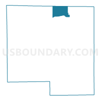
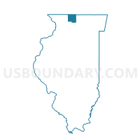
ROCKTON 7 Voting District, Winnebago County, Illinois
About
Outline

Summary
| Unique Area Identifier | 575855 |
| Name | ROCKTON 7 Voting District |
| County | Winnebago County |
| State | Illinois |
| Area (square miles) | 10.88 |
| Land Area (square miles) | 10.78 |
| Water Area (square miles) | 0.11 |
| % of Land Area | 99.03 |
| % of Water Area | 0.97 |
| Latitude of the Internal Point | 42.47987570 |
| Longtitude of the Internal Point | -89.11845660 |
Maps

Graphs
Select a template below for downloading or customizing gragh for ROCKTON 7 Voting District, Winnebago County, Illinois


Neighbors
Neighoring Voting District (by Name) Neighboring Voting District on the Map
- BELOIT - T 2 Voting District, Rock County, WI
- NEWARK - T 2 Voting District, Rock County, WI
- ROCKTON 1 Voting District, Winnebago County, IL
- ROCKTON 2 Voting District, Winnebago County, IL
- ROCKTON 4 Voting District, Winnebago County, IL
- SHIRLAND 1 Voting District, Winnebago County, IL
Top 10 Neighboring County Subdivision (by Population) Neighboring County Subdivision on the Map
- Rockton township, Winnebago County, IL (16,441)
- Beloit town, Rock County, WI (7,662)
- Newark town, Rock County, WI (1,541)
- Shirland township, Winnebago County, IL (988)
Top 10 Neighboring Place (by Population) Neighboring Place on the Map
Top 10 Neighboring Elementary School District (by Population) Neighboring Elementary School District on the Map
- Rockton School District 140, IL (12,459)
- Shirland Community Consolidated School District 134, IL (1,379)
Top 10 Neighboring Secondary School District (by Population) Neighboring Secondary School District on the Map
Top 10 Neighboring Unified School District (by Population) Neighboring Unified School District on the Map
- Beloit Turner School District, WI (8,833)
- South Beloit Community Unit School District 320, IL (6,409)
- Parkview School District, WI (6,093)
Top 10 Neighboring State Legislative District Lower Chamber (by Population) Neighboring State Legislative District Lower Chamber on the Map
Top 10 Neighboring State Legislative District Upper Chamber (by Population) Neighboring State Legislative District Upper Chamber on the Map
Top 10 Neighboring 111th Congressional District (by Population) Neighboring 111th Congressional District on the Map
Top 10 Neighboring Census Tract (by Population) Neighboring Census Tract on the Map
- Census Tract 40.02, Winnebago County, IL (6,959)
- Census Tract 41, Winnebago County, IL (5,302)
- Census Tract 39.01, Winnebago County, IL (4,838)
- Census Tract 27, Rock County, WI (2,571)
- Census Tract 22, Rock County, WI (2,307)
- Census Tract 40.03, Winnebago County, IL (1,980)